All articles published by MDPI are made immediately available worldwide under an open access license. No special
permission is required to reuse all or part of the article published by MDPI, including figures and tables. For
articles published under an open access Creative Common CC BY license, any part of the article may be reused without
permission provided that the original article is clearly cited. For more information, please refer to
https://www.mdpi.com/openaccess.
Feature papers represent the most advanced research with significant potential for high impact in the field. A Feature
Paper should be a substantial original Article that involves several techniques or approaches, provides an outlook for
future research directions and describes possible research applications.
Feature papers are submitted upon individual invitation or recommendation by the scientific editors and must receive
positive feedback from the reviewers.
Editor’s Choice articles are based on recommendations by the scientific editors of MDPI journals from around the world.
Editors select a small number of articles recently published in the journal that they believe will be particularly
interesting to readers, or important in the respective research area. The aim is to provide a snapshot of some of the
most exciting work published in the various research areas of the journal.
Pulmonary arterial hypertension (PAH) remains a significant challenge in cardiology, necessitating advancements in treatment strategies. This study explores the safety and efficacy of transitioning patients from beraprost to selexipag, a novel selective prostacyclin receptor agonist, within a Japanese cohort. Employing a multicenter, open-label,
[...] Read more.
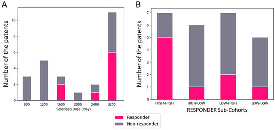
Pulmonary arterial hypertension (PAH) remains a significant challenge in cardiology, necessitating advancements in treatment strategies. This study explores the safety and efficacy of transitioning patients from beraprost to selexipag, a novel selective prostacyclin receptor agonist, within a Japanese cohort. Employing a multicenter, open-label, prospective design, 25 PAH patients inadequately managed on beraprost were switched to selexipag. Key inclusion criteria included ongoing beraprost therapy for ≥3 months, a diagnosis of PAH confirmed by mean pulmonary artery pressure (mPAP) ≥ 25 mmHg, and current treatment with endothelin receptor antagonists and/or phosphodiesterase type 5 inhibitors. Outcomes assessed were changes in hemodynamic parameters (mPAP, cardiac index, pulmonary vascular resistance) and the 6 min walk distance (6-MWD) over 3–6 months. The study found no statistically significant changes in these parameters post-switch. However, a subset of patients, defined as responders, demonstrated improvements in all measured hemodynamic parameters, suggesting a potential benefit in carefully selected patients. The transition was generally well-tolerated with no serious adverse events reported. This investigation underscores the importance of personalized treatment strategies in PAH, highlighting that certain patients may benefit from switching to selexipag, particularly those previously on higher doses of beraprost. Further research is needed to elucidate the predictors of positive response to selexipag and optimize treatment regimens for this complex condition.
Full article
The Ozone Monitoring Suite-Nadir (OMS-N) instrument is the first hyperspectral remote sensor in the ultraviolet band of China’s Fengyun series satellites. It can be used to detect several kinds of atmospheric constituents. This paper describes the prelaunch spectral calibration of the OMS-N onboard
[...] Read more.
The Ozone Monitoring Suite-Nadir (OMS-N) instrument is the first hyperspectral remote sensor in the ultraviolet band of China’s Fengyun series satellites. It can be used to detect several kinds of atmospheric constituents. This paper describes the prelaunch spectral calibration of the OMS-N onboard FengYun 3F. Several critical spectral parameters including the spectral resolution, spectral dispersion, and the instrument spectral response function were determined through laser-based measurements. A secondary peak of the instrument spectral response function from the short wavelength side of the ultraviolet band was found, and the possible influence on data applications was analyzed using a reference solar model and radiative transfer model. The results indicate that the spectral resolution and spectral accuracy of OMS-N meet the mission requirements. However, the asymmetries in the instrument spectral response function in the ultraviolet band were found near nadir rows, which are expressed as the “asymmetric central peak” and “secondary peak”. The analysis results show that if the influences of the instrument spectral response function “asymmetric central peak” and “secondary peak” in the ultraviolet band are ignored, they will bring an error as large as 5% at the center of the absorption line.
Full article
As the demand for precise navigation of aircraft increases in modern society, researching high-precision, high-autonomy navigation systems is both theoretically valuable and practically significant. Because the inertial navigation system (INS) has systematic and random errors, its output information diverges. Therefore, it is necessary
[...] Read more.
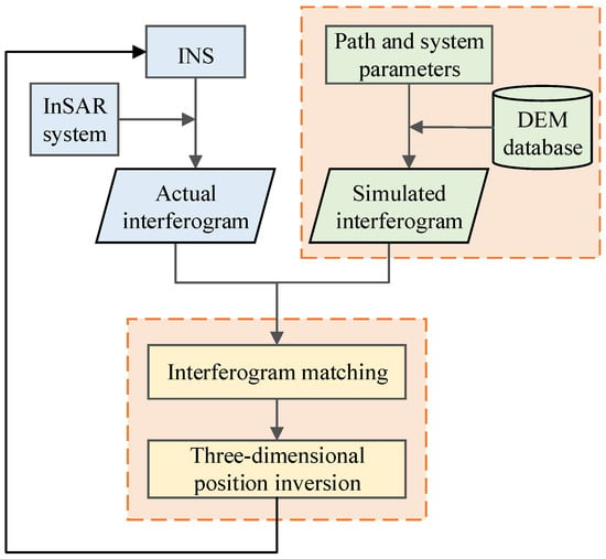
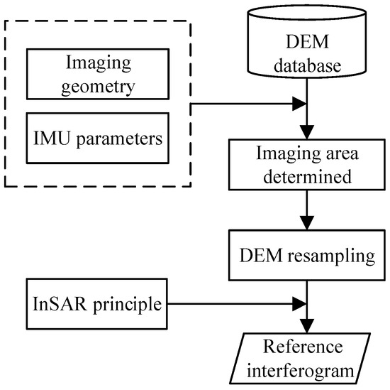
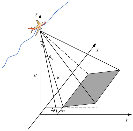
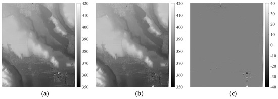
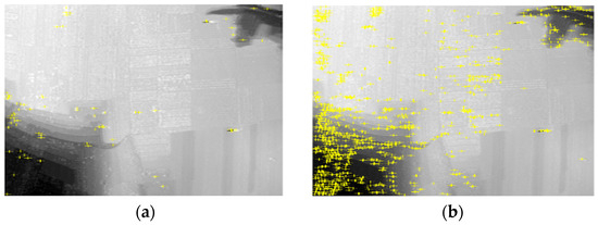
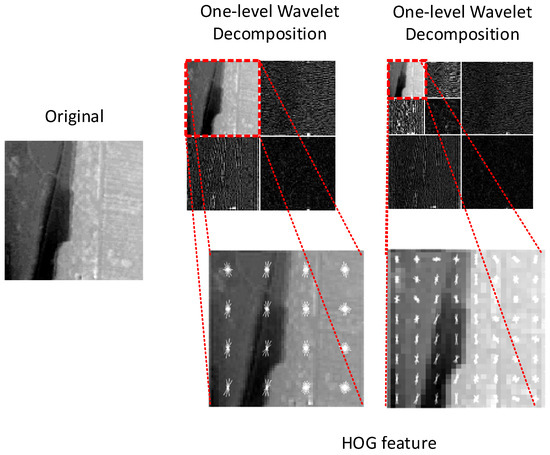
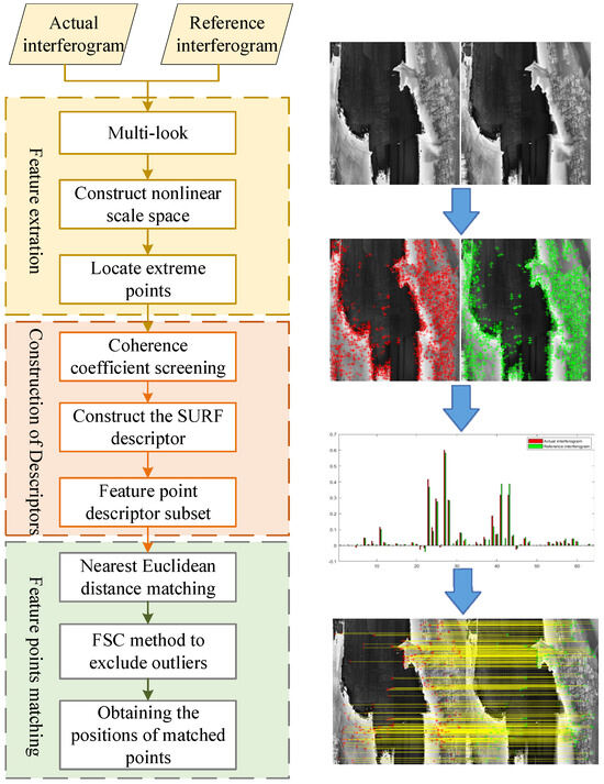
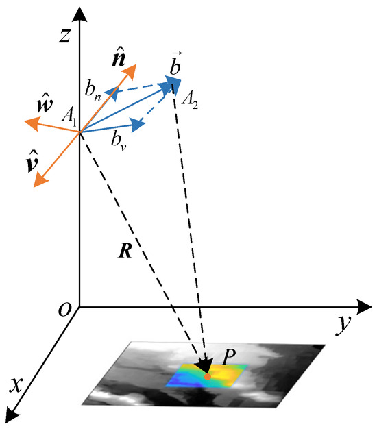
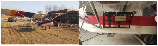
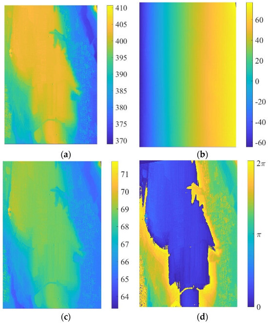
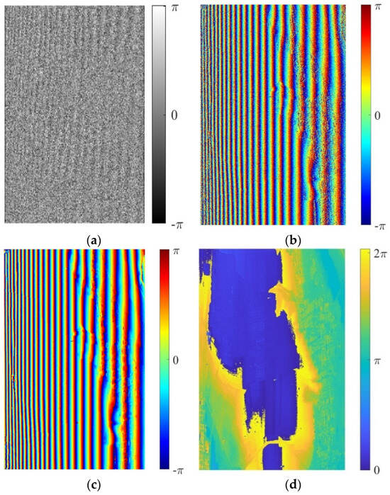
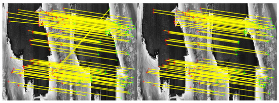
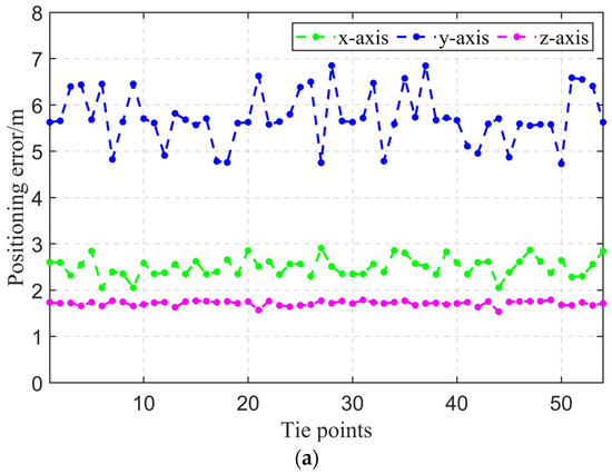
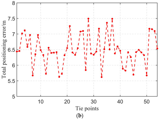
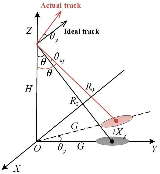
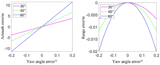
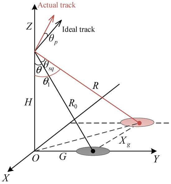
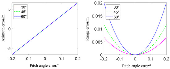
As the demand for precise navigation of aircraft increases in modern society, researching high-precision, high-autonomy navigation systems is both theoretically valuable and practically significant. Because the inertial navigation system (INS) has systematic and random errors, its output information diverges. Therefore, it is necessary to combine them with other navigation systems for real-time compensation and correction of these errors. The SAR matching positioning and navigation system uses synthetic aperture radar (SAR) image matching for platform positioning and compensates for the drift caused by errors in the inertial measurement unit (IMU). Images obtained by SAR are matched with digital landmark data, and the platform’s position is calculated based on the SAR imaging geometry. However, SAR matching positioning faces challenges due to seasonal variations in SAR images, the need for typical landmarks for matching, and the lack of elevation information in two-dimensional SAR image matching. This paper proposes an airborne platform positioning method based on interferometric SAR (InSAR) interferogram matching. InSAR interferograms contain terrain elevation information, are less affected by seasonal changes, and provide higher positioning accuracy and robustness. By matching real-time InSAR-processed interferograms with simulated interferograms using a digital elevation model (DEM), three-dimensional position information about the matching points has been obtained. Subsequently, a three-dimensional positioning model for the platform has bene established using the unit line-of-sight vector decomposition method. In actual flight experiments using an FMCW Ku-band Interferometric SAR system, the proposed platform positioning framework demonstrated its ability to achieve precise positioning in the absence of signals from the global navigation satellite system (GNSS).
Full article
Cities play a crucial role in the carbon cycle. Measuring urban aboveground biomass (AGB) is essential for evaluating carbon sequestration. Satellite remote sensing enables large-scale AGB inversion. However, the apparent differences between forest and grassland biomass pose a significant challenge to the accurate
[...] Read more.
Cities play a crucial role in the carbon cycle. Measuring urban aboveground biomass (AGB) is essential for evaluating carbon sequestration. Satellite remote sensing enables large-scale AGB inversion. However, the apparent differences between forest and grassland biomass pose a significant challenge to the accurate estimation of urban AGB using satellite-based data. To address this limitation, this study proposed a novel AGB estimation method using the eastern part of the Zhahe mining area in Huaibei City as the study area, which integrates land cover classification, feature selection, and machine learning modelling to generate high quality biomass maps of different vegetation types in an urban area with complex feature distribution. Utilizing the GEE platform and Sentinel-2 image, we developed an object-oriented machine learning classification algorithm, combining SNIC and GLCM to extract vegetation information. Optimal feature variables for forest and crop-grass AGB inversion were selected using the Pearson–mRMR algorithm. Finally, we constructed nine machine learning models for AGB inversion and selected the model with the highest accuracy to generate the AGB map of the study area. The results of the study are as follows: (1) Compared with the pixel-based classification method, the object-oriented classification method can extract the boundaries of different vegetation types more accurately. (2) Forest AGB is strongly correlated with vegetation indices and physiological parameters, while agri-grass AGB is primarily associated with vegetation indices and vegetation physiological parameters. (3) For forest AGB modelling, the RF-R model outperforms other machine learning models with an R2 of 0.77. For agri-grass AGB modelling, the XGBoost-R model is more accurate, with an R2 of 0.86. (4) The mean forest AGB in the study area was 4.60 kg/m2, while the mean agri-grass AGB was 0.71 kg/m2. High AGB values were predominantly observed in forested areas, which were mainly distributed along roads, waterways, and mountain ranges. Overall, this study contributes to a better understanding of the health of local urban ecosystems and provides valuable insights for ecosystem protection and the sustainable use of natural resources.
Full article
Research on wildlife monitoring methods is a crucial tool for the conservation of rare wildlife in China. However, the fact that rare wildlife monitoring images in field scenes are easily affected by complex scene information, poorly illuminated, obscured, and blurred limits their use.
[...] Read more.
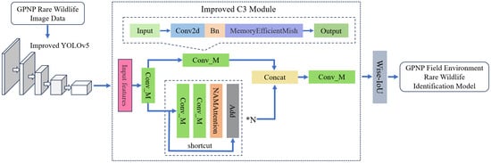
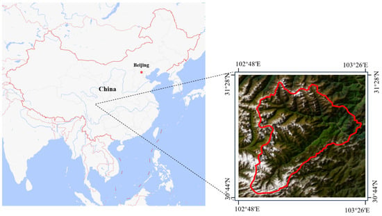
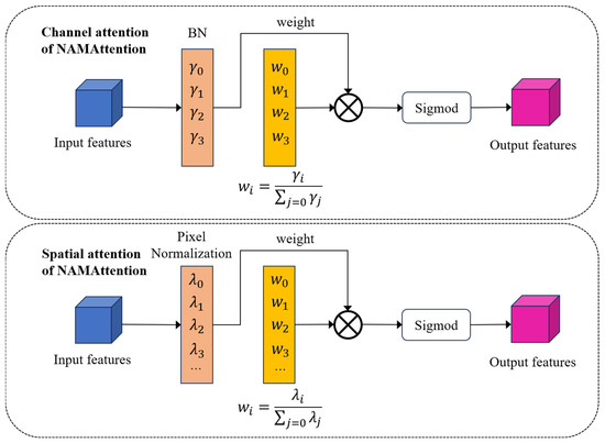
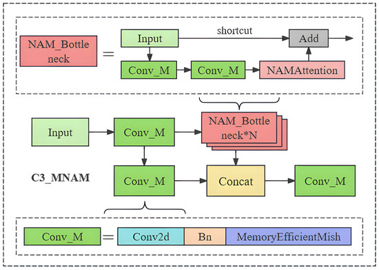
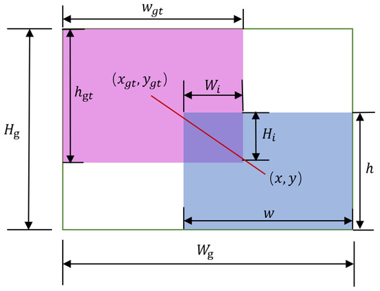
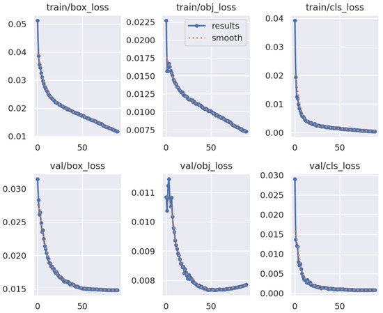
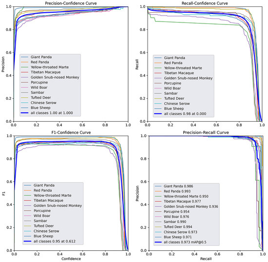
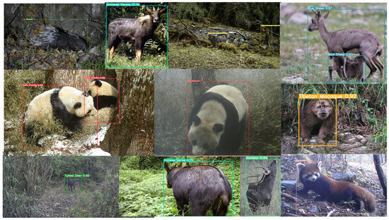
Research on wildlife monitoring methods is a crucial tool for the conservation of rare wildlife in China. However, the fact that rare wildlife monitoring images in field scenes are easily affected by complex scene information, poorly illuminated, obscured, and blurred limits their use. This often results in unstable recognition and low accuracy levels. To address this issue, this paper proposes a novel wildlife identification model for rare animals in Giant Panda National Park (GPNP). We redesigned the C3 module of YOLOv5 using NAMAttention and the MemoryEfficientMish activation function to decrease the weight of field scene features. Additionally, we integrated the WIoU boundary loss function to mitigate the influence of low-quality images during training, resulting in the development of the NMW-YOLOv5 model. Our model achieved 97.3% for mAP50 and 83.3% for mAP50:95 in the LoTE-Animal dataset. When comparing the model with some classical YOLO models for the purpose of conducting comparison experiments, it surpasses the current best-performing model by 1.6% for mAP50:95, showcasing a high level of recognition accuracy. In the generalization ability test, the model has a low error rate for most rare wildlife species and is generally able to identify wildlife in the wild environment of the GPNP with greater accuracy. It has been demonstrated that NMW-YOLOv5 significantly enhances wildlife recognition accuracy in field environments by eliminating irrelevant features and extracting deep, effective features. Furthermore, it exhibits strong detection and recognition capabilities for rare wildlife in GPNP field environments. This could offer a new and effective tool for rare wildlife monitoring in GPNP.
Full article
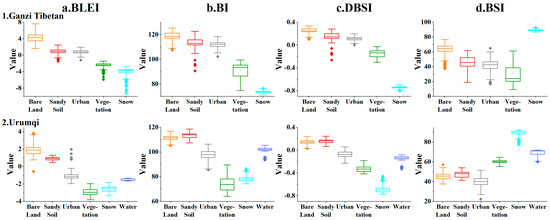
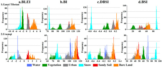
Bare land, as a significant land cover type on the Earth’s surface, plays a crucial role in supporting land-use planning, urban management, and ecological environmental research through the investigation of its spatial distribution. However, due to the diversity of land-cover types on the
[...] Read more.
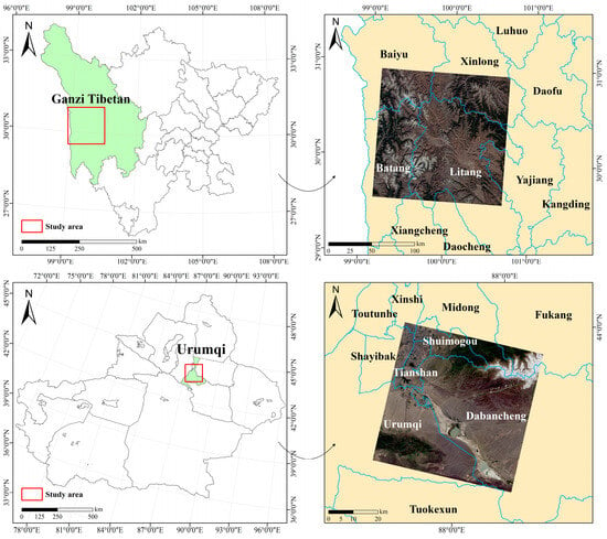
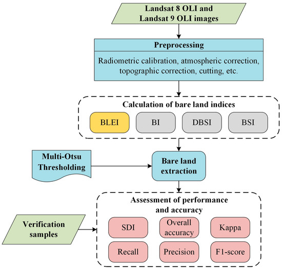
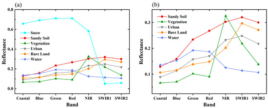
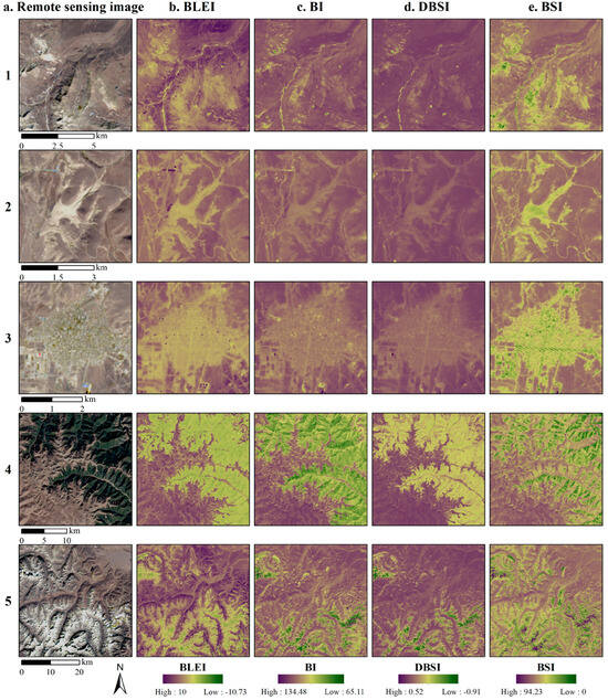
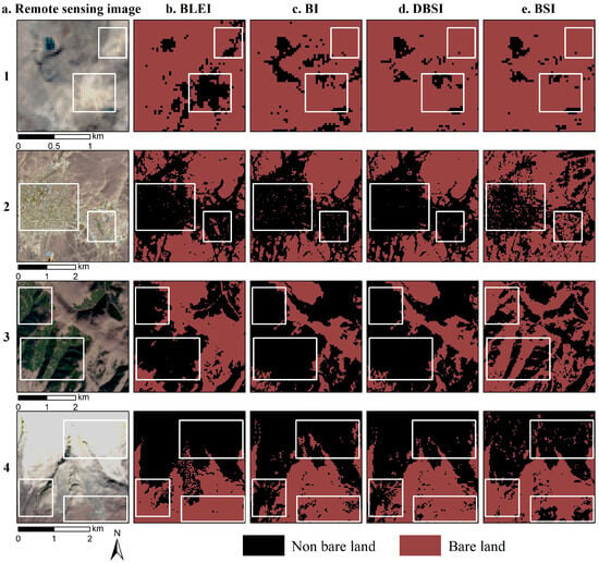
Bare land, as a significant land cover type on the Earth’s surface, plays a crucial role in supporting land-use planning, urban management, and ecological environmental research through the investigation of its spatial distribution. However, due to the diversity of land-cover types on the Earth’s surface and the spectral complexity exhibited by bare land under the influence of environmental factors, it is prone to confusion with urban and other land features. In order to extract bare land rapidly and efficiently, this study introduces a novel bare land extraction index called the Bare Land Extraction Index (BLEI). Then, considering both Ganzi Tibetan Autonomous Prefecture and Urumqi, China as the study areas, we compared BLEI with three presented indices: the Bare-soil Index (BI), Dry Bare Soil Index (DBSI), and Bare Soil Index (BSI). The results show that BLEI exhibits excellent efficacy in distinguishing bare land and urban areas. It gets the most outstanding accuracy in bare land identification and mapping, with overall accuracy (OA), kappa coefficient, and F1-score of 98.91%, 0.97, and 97.89%, respectively. Furthermore, BLEI is also effective in distinguishing bare land from sandy soil, which can not only improve the mapping accuracy of bare land in soil-deserted areas but also provide technological support for soil research and land-use planning.
Full article
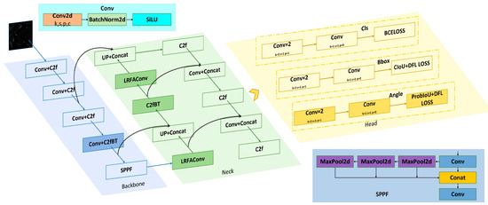
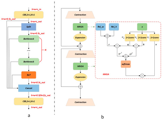
Synthetic Aperture Radar (SAR) has the advantage of continuous observation throughout the day and in all weather conditions, and is used in a wide range of military and civil applications. Among these, the detection of ships at sea is an important research topic.
[...] Read more.
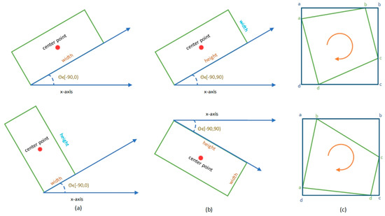
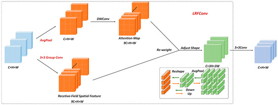
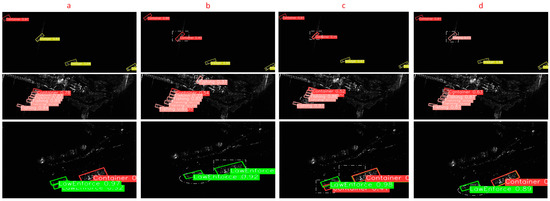
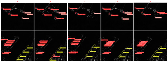
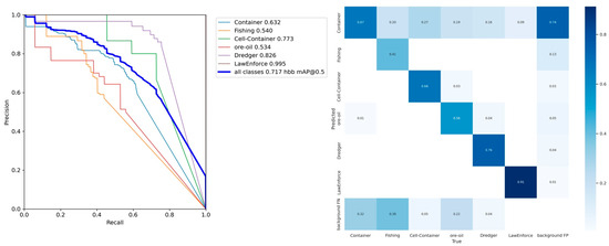
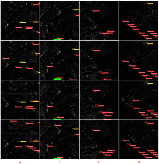
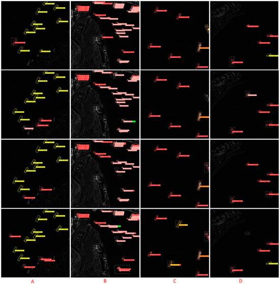
Synthetic Aperture Radar (SAR) has the advantage of continuous observation throughout the day and in all weather conditions, and is used in a wide range of military and civil applications. Among these, the detection of ships at sea is an important research topic. Ships in SAR images are characterized by dense alignment, an arbitrary orientation and multiple scales. The existing detection algorithms are unable to solve these problems effectively. To address these issues, A YOLOV8-based oriented ship detection and classification method using SAR imaging with lightweight receptor field feature convolution, bottleneck transformers and a probabilistic intersection-over-union network (R-LRBPNet) is proposed in this paper. First, a CSP bottleneck with two bottleneck transformer (C2fBT) modules based on bottleneck transformers is proposed; this is an improved feature fusion module that integrates the global spatial features of bottleneck transformers and the rich channel features of C2f. This effectively reduces the negative impact of densely arranged scenarios. Second, we propose an angle decoupling module. This module uses probabilistic intersection-over-union (ProbIoU) and distribution focal loss (DFL) methods to compute the rotated intersection-over-union (RIoU), which effectively alleviates the problem of angle regression and the imbalance between angle regression and other regression tasks. Third, the lightweight receptive field feature convolution (LRFConv) is designed to replace the conventional convolution in the neck. This module can dynamically adjust the receptive field according to the target scale and calculate the feature pixel weights based on the input feature map. Through this module, the network can efficiently extract details and important information about ships to improve the classification performance of the ship. We conducted extensive experiments on the complex scene SAR dataset SRSDD and SSDD+. The experimental results show that R-LRBPNet has only 6.8 MB of model memory, which can achieve 78.2% detection accuracy, 64.2% recall, a 70.51 F1-Score and 71.85% mAP on the SRSDD dataset.
Full article
Weakly supervised object detection (WSOD) in remote sensing images (RSIs) aims to detect high-value targets by solely utilizing image-level category labels; however, two problems have not been well addressed by existing methods. Firstly, the seed instances (SIs) are mined solely relying on the
[...] Read more.
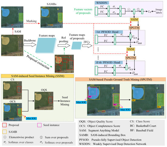
Weakly supervised object detection (WSOD) in remote sensing images (RSIs) aims to detect high-value targets by solely utilizing image-level category labels; however, two problems have not been well addressed by existing methods. Firstly, the seed instances (SIs) are mined solely relying on the category score (CS) of each proposal, which is inclined to concentrate on the most salient parts of the object; furthermore, they are unreliable because the robustness of the CS is not sufficient due to the fact that the inter-category similarity and intra-category diversity are more serious in RSIs. Secondly, the localization accuracy is limited by the proposals generated by the selective search or edge box algorithm. To address the first problem, a segment anything model (SAM)-induced seed instance-mining (SSIM) module is proposed, which mines the SIs according to the object quality score, which indicates the comprehensive characteristic of the category and the completeness of the object. To handle the second problem, a SAM-based pseudo-ground truth-mining (SPGTM) module is proposed to mine the pseudo-ground truth (PGT) instances, for which the localization is more accurate than traditional proposals by fully making use of the advantages of SAM, and the object-detection heads are trained by the PGT instances in a fully supervised manner. The ablation studies show the effectiveness of the SSIM and SPGTM modules. Comprehensive comparisons with 15 WSOD methods demonstrate the superiority of our method on two RSI datasets.
Full article
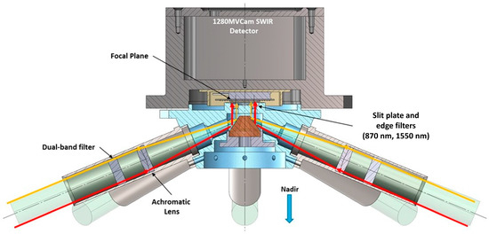
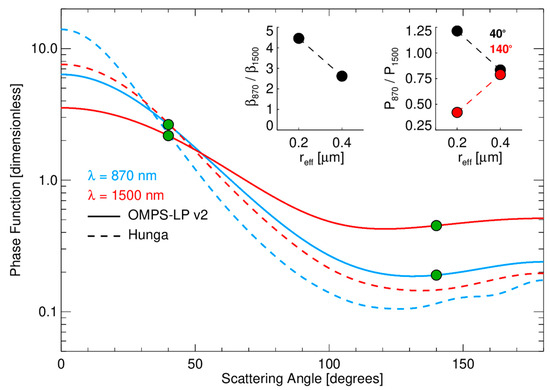
Atmospheric aerosols represent an important component of the Earth’s climate system because they can contribute both positive and negative forcing to the energy budget. We are developing the Aerosol Radiometer for Global Observations of the Stratosphere (ARGOS) instrument to provide improved measurements of
[...] Read more.
Atmospheric aerosols represent an important component of the Earth’s climate system because they can contribute both positive and negative forcing to the energy budget. We are developing the Aerosol Radiometer for Global Observations of the Stratosphere (ARGOS) instrument to provide improved measurements of stratospheric aerosols in a compact package. ARGOS makes limb scattering measurements from space in eight directions simultaneously, using two near-IR wavelengths for each viewing direction. The combination of forward and backward scattering views along the orbit track gives additional information to constrain the aerosol phase function and size distribution. Cross-track views provide expanded spatial coverage. ARGOS will have a demonstration flight through a hosted payload provider in the fall of 2024. The instrument has completed pre-launch environmental testing and radiometric characterization tests. The hosted payload approach offers advantages in size, weight, and power margins for instrument design compared to other approaches, with significant benefits in terms of reducing infrastructure requirements for the instrument team.
Full article
This study introduces a novel benchmark model for lithium iron phosphate (LFP) batteries in reactive energy imbalance markets, filling a notable gap by incorporating comprehensive operational parameters and market dynamics that are overlooked by conventional models. Addressing the absence of a holistic benchmark
[...] Read more.
This study introduces a novel benchmark model for lithium iron phosphate (LFP) batteries in reactive energy imbalance markets, filling a notable gap by incorporating comprehensive operational parameters and market dynamics that are overlooked by conventional models. Addressing the absence of a holistic benchmark for energy-storage systems in electricity markets, this research focuses on the integration of LFP batteries, considering their unique characteristics and market responsiveness. Regression and regularization techniques, coupled with temporal cross-validation, were employed to ensure model robustness and accuracy in predicting energy trading outcomes. This methodological approach allows for a nuanced analysis of battery degradation, power capacity, energy content, and real-time market prices. The model, validated using Belgium’s system imbalance market data from the 2020–2023 period, incorporates both capital and operational expenditures to assess the economic and operational viability of LFP battery energy-storage systems (BESSs). The findings reveal that considering a broader range of operational parameters in energy arbitrage, beyond just the usual energy prices and round-trip efficiency, significantly influences the cost-effectiveness and performance benchmarking of energy storage solutions. This paper advocates for the strategic use of LFP batteries in energy markets, highlighting their potential to enhance grid stability and energy trading profitability. The proposed benchmark model serves as a critical tool for energy traders, providing a detailed framework for informed decision making in the evolving landscape of energy storage technologies.
Full article
This article analyzes the correlation between the city size, population density and character of three Polish cities and the following aspects: (1) inhabitants’ subjective stress level and its change during the COVID-19 pandemic, (2) sources and effects of their stress during the pandemic,
[...] Read more.
This article analyzes the correlation between the city size, population density and character of three Polish cities and the following aspects: (1) inhabitants’ subjective stress level and its change during the COVID-19 pandemic, (2) sources and effects of their stress during the pandemic, (3) ways of reducing stress by residents and the role of greenery in this respect and (4) directions of changes in the structure of post-pandemic cities desired by their residents. The main research method was geo-surveys, the results of which were developed using statistical analysis and GIS methods. On the basis of the constructed scale, respondents subjectively assessed the level of experienced stress and its change during the COVID-19 pandemic. The research shows that none of the considered features of cities (including size measured by the number of inhabitants) are related to the level of pandemic stress of their inhabitants. All of them, on the other hand, are correlated with the directions of urban spatial development desired by the residents, conducive to stress reduction. Furthermore, the size of the city and its character affect the subjectively perceived change in stress levels during the pandemic (compared to the stress level before pandemic). Some of the effects of pandemic stress and ways of reducing it depend on the character of the city. The stress experienced by the inhabitants is the lowest in cities with the largest share of green areas in the spatial structure (especially with forest complexes and naturally shaped areas of river valleys), where an effective system of greenery has been adopted (the Howard’s garden city model), and at the same time with dominant single-family housing. The research results were used to indicate new directions for shaping post-pandemic cities that are more resistant to stress and thus healthier for their residents.
Full article
by
Andrea Gianni Cristoforo Nardini, Constanza Gonzalez, Angela Contreras, Germán Velásquez, José Vargas-Baecheler, Hervé Piégay, Joaquin Espinoza and Santiago Yépez
In recent decades, the interplay of several factors, including land use change (particularly urbanization) and global warming, has resulted in harsher flooding, often associated with geomorphic disruption. These events in Latin America are predominantly driven by the El Niño Southern Oscillation (ENSO) phenomenon.
[...] Read more.
In recent decades, the interplay of several factors, including land use change (particularly urbanization) and global warming, has resulted in harsher flooding, often associated with geomorphic disruption. These events in Latin America are predominantly driven by the El Niño Southern Oscillation (ENSO) phenomenon. The Andalién River basin is no exception, with a notable incident occurring in July 2006. This reality points out the need to study the geomorphological behavior of rivers. Geomatic tools can contribute to address this issue, thereby improving the planning and management of water courses. This paper presents the assessment of the morphological evolution of the Andalién River, downstream to the city of Concepción in a period of 75 years (1945–2020), in response to changes in land use and anthropogenic interventions on the river itself. Based on temporal satellite imagery and historical aerial images (from 1945 to 2020) combined with digital elevation models (LiDAR and TamDEM-X data), morphological alterations are revealed, which were caused by urbanization and anthropogenic activities. We demonstrate how the South River Toolbox (SRT), an original GIS tool developing in QGIS (in-house), enables the extraction of key geomorphological features of a river and their analysis, including their time evolution. This retrospective analysis includes an innovative method and tool to measure the lateral migration rate of the active channel. Ultimately, this study provides valuable insights for future management strategies, offering a comprehensive basin-level analysis of the Andalién River and a cartographic framework to aid decision-making, planning, and management of the fluvial corridor.
Full article
To further study the spatial distribution and dynamic evolution of carbon emissions from animal husbandry in Shandong Province, the panel data of 16 prefecture-level cities in Shandong Province from 2001 to 2022 were used to measure the carbon emissions of animal husbandry and
[...] Read more.
To further study the spatial distribution and dynamic evolution of carbon emissions from animal husbandry in Shandong Province, the panel data of 16 prefecture-level cities in Shandong Province from 2001 to 2022 were used to measure the carbon emissions of animal husbandry and the carbon emission intensity of animal husbandry. Based on the combination of space, kernel density estimation, and LMDI decomposition model, the spatial and temporal evolution of carbon emissions from animal husbandry in Shandong Province and its driving factors were investigated. The results show that: (1) The total amount of animal husbandry carbon emissions in Shandong Province showed a fluctuating downward trend, with a decrease of 10.10% during the investigation period, showing a peripheral-agglomeration distribution pattern. The carbon emission intensity showed a gradual downward trend, with an average annual decline of 7.47%, showing stepped distribution characteristics of high in the west and low in the east. (2) The difference in carbon emissions of animal husbandry among cities in Shandong Province increased first and then decreased, and the growth distribution was basically in the form of “bimodal”, showing a polarization pattern. (3) The intensity effect has the most obvious inhibitory effect on the carbon emission of animal husbandry; the effect of agricultural structure changes from a promoting effect to an inhibiting effect. The inhibitory effect of the industrial structure effect is second only to the intensity effect; the economic effect has the greatest promoting effect; and the promotion effect of the population size effect is small.
Full article
The railway plays an essential role in urban and intercity transport of goods and people. Intercity and urban rail transit infrastructures contribute to the economic and environmental sustainability of global economies. Those infrastructures can be modeled as complex networks, so that we can
[...] Read more.
The railway plays an essential role in urban and intercity transport of goods and people. Intercity and urban rail transit infrastructures contribute to the economic and environmental sustainability of global economies. Those infrastructures can be modeled as complex networks, so that we can evaluate system properties of the network structure. This stream of research has focused on the topological analysis of global network structure, but little research exists that examines how local network structures affect system properties. The local structure of complex networks can be examined with network motif analysis, as those network motifs are the building blocks of networked systems. Nevertheless, there has been scarce attention given to local network properties in rail transit networks. We contribute to covering this gap in the literature with a literature review of motif analysis research and its application to weighted and unweighted rail transit networks, also covering the current state-of-the-art of network motif decomposition and analysis. We demonstrate that network motif analysis is not only applicable, but also beneficial for the design and planning of rail transit networks, enhancing their sustainability by improving efficiency, reducing environmental impact, and optimizing resource allocation. Based on our findings, we propose future research directions that involve applying motif analysis to enhance the sustainability features of both unweighted and weighted rail transit networks.
Full article
The promotion and development of healthy cities are vital for enhancing human habitats and fostering sustainable economic growth. Based on the core databases of Web of Science, PubMed, Google Scholar, and PsycINFO, and the knowledge graph software, this paper presents a quantitative analysis
[...] Read more.
The promotion and development of healthy cities are vital for enhancing human habitats and fostering sustainable economic growth. Based on the core databases of Web of Science, PubMed, Google Scholar, and PsycINFO, and the knowledge graph software, this paper presents a quantitative analysis of the literature related to attention recovery abroad. It is found that in recent years, the research on attention recovery has developed rapidly, the number of related studies has been increasing, and the research content presents the characteristics of interdisciplinary integration. By further analyzing the characteristics of the research literature, research context, and knowledge basis, this paper summarizes the empirical research based on the existing quantitative analysis, reviews the research field based on the mechanism of attention recovery, and analyzes the development process and trend based on the research basis of attention recovery. Due to the change in the modern life style, human health problems are becoming more and more prominent. Attention restoration design provides a new research idea and method to balance the relationship between humans and the urban environment.
Full article
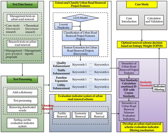
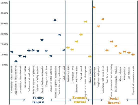
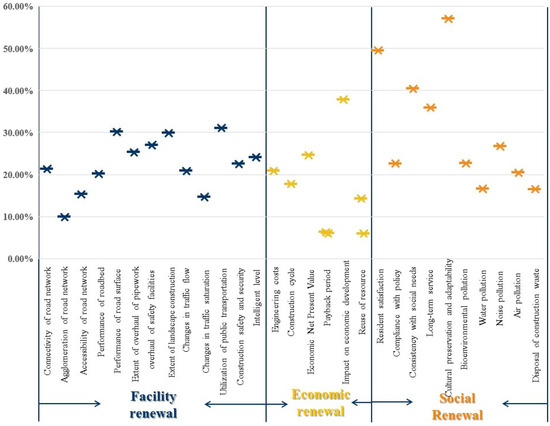
As global urban infrastructure renewal progresses, the urgent need for sustainability-driven urban renewal intensifies amidst resource scarcity and environmental concerns. Effective evaluation and decision making regarding urban road renewal schemes are prerequisites for their successful implementation. However, variation in the prioritization of indicators
[...] Read more.
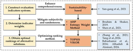
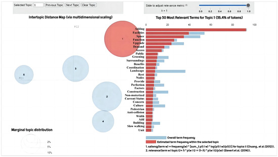
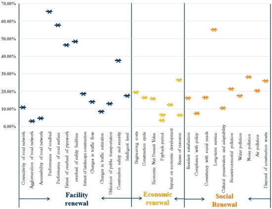
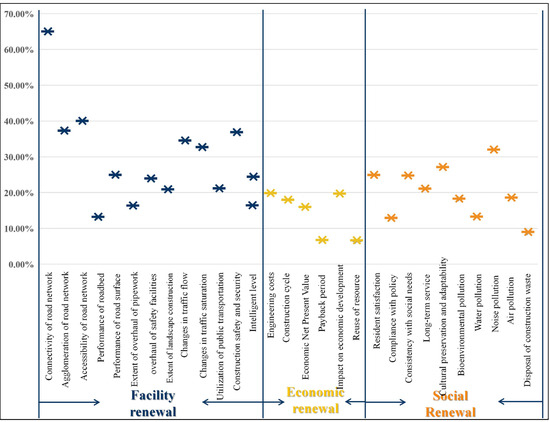
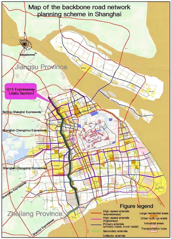
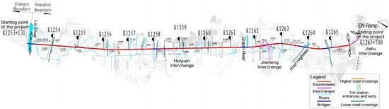
As global urban infrastructure renewal progresses, the urgent need for sustainability-driven urban renewal intensifies amidst resource scarcity and environmental concerns. Effective evaluation and decision making regarding urban road renewal schemes are prerequisites for their successful implementation. However, variation in the prioritization of indicators in project evaluations and the poor adaptability of existing frameworks hinder the quick assessment of diverse projects. To address this issue, this paper proposes a scheme evaluation framework with embedded renewal project features comprising four modules. Following the initial construction of a sustainability-driven evaluation system, an indicator-filtering mechanism combining the Latent Dirichlet Allocation (LDA) model with a text similarity algorithm is developed. The Entropy Weight-–TOPSIS method is then employed to derive the final optimal decision based on selected indicators. Applying the decision framework to the G15 Jialiu Widening and Reconstruction Project in Shanghai, China, indicators are reduced by 48.3%, with the optimal scheme decision consistent with the traditional Entropy Weight–TOPSIS method. The framework is robust and enhances decision efficiency, filling theoretical gaps in existing indicator-filtering mechanisms.
Full article
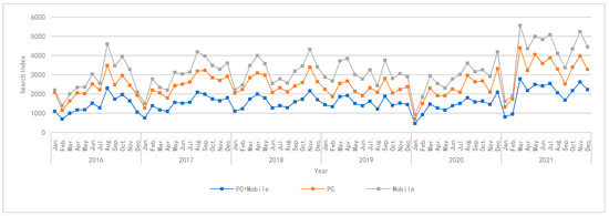
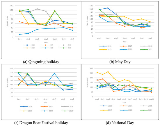
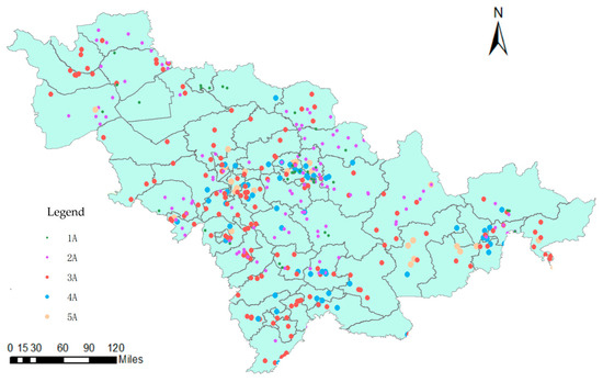
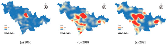
The digital age provides greater possibilities for quantitative research on rural tourism. This article examines Jilin Province as a case and analyzes the interannual, monthly, and holiday characteristics of rural tourism heat using big data. Using A-level rural tourism operating units as research
[...] Read more.
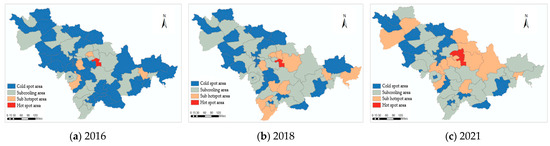
The digital age provides greater possibilities for quantitative research on rural tourism. This article examines Jilin Province as a case and analyzes the interannual, monthly, and holiday characteristics of rural tourism heat using big data. Using A-level rural tourism operating units as research samples, a mathematical model is constructed to evaluate the rural tourism heat from 2016 to 2021. Through a trend surface analysis and kernel density analysis, the spatiotemporal differentiation characteristics are explored; additionally, the spatial evolution law of the rural tourism hot and cold pattern is analyzed using counties as units. The research results show the following: (1) As an important component of the Jilin tourism industry, temporally, rural tourism has an overall trend of increasing popularity, with clear seasonal and holiday distribution patterns. Simultaneously, the periodic sporadic occurrence of the COVID-19 epidemic caused an obvious vulnerability in rural tourism fever. (2) Spatially, the structure of rural tourism shows an evolutionary process of “single core → multi core” and a diffusion trend of “central → eastern” and “central → western”. (3) Regarding the influencing factors, transportation conditions and resource endowments are dominant, and the impact of the economic development level is gradually weakening, while the impact of the ecological environment and industrial foundation is gradually increasing.
Full article
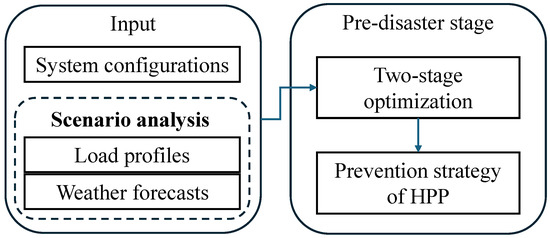
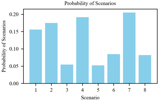
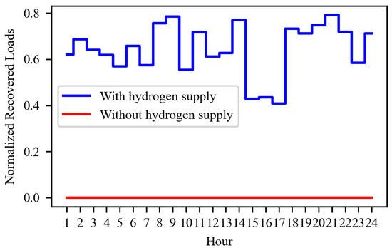
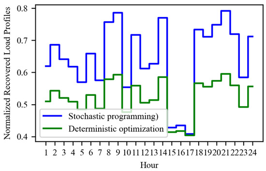
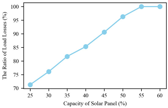
The increasing occurrence of severe weather phenomena presents substantial difficulties for electricity distribution systems. This study investigates the integration of hydrogen production plants (HPPs) into power distribution networks to bolster resilience against the increasing frequency of extreme weather events. It highlights the innovative
[...] Read more.
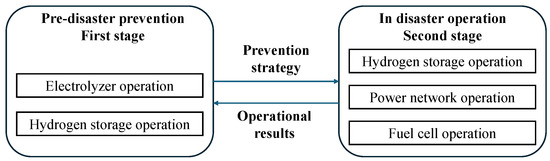
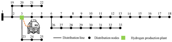
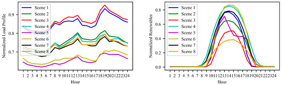
The increasing occurrence of severe weather phenomena presents substantial difficulties for electricity distribution systems. This study investigates the integration of hydrogen production plants (HPPs) into power distribution networks to bolster resilience against the increasing frequency of extreme weather events. It highlights the innovative use of hydrogen, generated from renewable sources, as an energy storage medium to ensure a stable power supply during disruptions. By employing stochastic optimization, the study aims to effectively manage hydrogen production and utilization, considering uncertainties in disaster scenarios and energy demands. It addresses critical research gaps, such as the lack of focus on pre-disaster preventive scheduling using hydrogen, the under-explored application of stochastic optimization in such contexts, and the predominance of real-time response strategies over pre-emptive measures. This approach significantly advances current understanding by proposing novel strategies that leverage hydrogen production and sophisticated optimization to enhance the resilience of power networks against extreme weather events. In some scenarios, using our method can reduce the cost of pre-disaster prevention by approximately 15.68% while ensuring that the disaster recovery effect remains unchanged.
Full article
Xinjiang is located in the arid region of northwestern China, and agriculture accounts for an absolute share of total water use. Resource-based, engineering, structural, and managed water shortages coexist. Therefore, it is of great significance to vigorously develop water conservation technology and improve
[...] Read more.
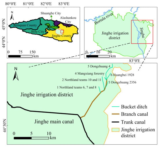
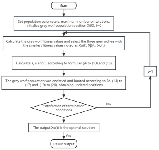
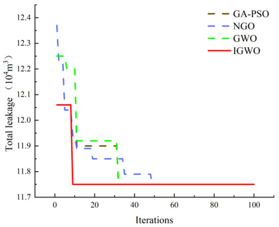
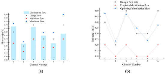
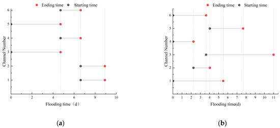
Xinjiang is located in the arid region of northwestern China, and agriculture accounts for an absolute share of total water use. Resource-based, engineering, structural, and managed water shortages coexist. Therefore, it is of great significance to vigorously develop water conservation technology and improve the efficiency of water transmission and distribution in canal systems. This research aims at addressing the problems of difficult manual regulation and the overall optimization of the final canal system, low-water-resource utilization efficiency, and management efficiency. Taking the branch-double two-stage canal system of Dongfeng branch canal in Mangxiang, Jinghe irrigation district, as a case study, and the rotation irrigation group and irrigation duration as decision variables, canal distribution is modeled with the goal of minimizing seepage losses. The improved grey wolf algorithm combined with particle swarm optimization is used for the first time and compared with the traditional grey wolf algorithm, genetic particle swarm optimization fusion algorithm, and northern goshawk algorithm. The results show that (1) on the basis of meeting the water discharge capacity and water demand requirements of the canal system, the diversion time of the water distribution scheme obtained by using the improved grey wolf algorithm is shortened from 11 d to 8.91 d compared with the traditional empirical water distribution scheme. (2) The improved grey wolf algorithm converges to the optimal value within 10 generations compared to the remaining methods, and the total water leakage is reduced from 16.15 × 10⁴ m3 to 11.75 × 10⁴ m3. (3) The number of gate adjustments is reduced, and the canal gates are opened and closed at the same time within each rotational irrigation group. The grey wolf algorithm improved by its combination with particle swarm has stronger optimization ability and convergence, which can better meet the requirements of efficient water resource allocation in irrigation canal systems, as well as a high application value.
Full article
Many Saudi students lack the motivation to pursue STEM careers due to their teachers’ limited experience and low efficacy in teaching science, technology, engineering, and mathematics (STEM). Teachers’ perceptions are central to efficient STEM education; however, little is known about the perceptions of
[...] Read more.
Many Saudi students lack the motivation to pursue STEM careers due to their teachers’ limited experience and low efficacy in teaching science, technology, engineering, and mathematics (STEM). Teachers’ perceptions are central to efficient STEM education; however, little is known about the perceptions of teachers toward STEM education in Saudi Arabia. Therefore, this study attempted to identify the perceptions of secondary stage science teachers toward STEM education and their knowledge about the requirements for its implementation. The study also investigated whether there were statistically significant differences that could be attributed to teachers’ qualifications, years of experience, and specialization variables. A questionnaire was applied to 175 in-service science teachers. The results showed that the secondary stage science teachers had a medium level of positive perceptions toward STEM education and a high level of knowledge about the requirements for its implementation. It was also revealed that there were statistically significant differences in teachers’ perceptions due to their qualifications and years of experience, in favor of teachers with graduate degrees and with more years of experience, while there were no statistically significant differences due to teachers’ specialization. Based on the findings of this study, a number of recommendations on improving science teachers’ knowledge of STEM education and the requirements for its implementation are provided.
Full article
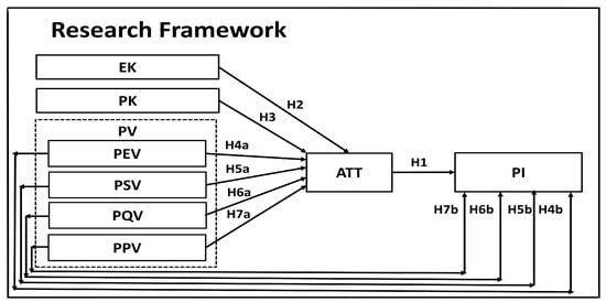
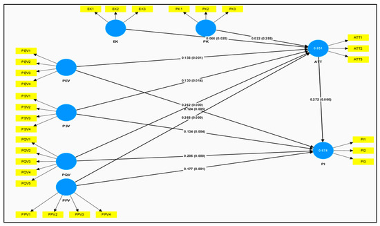
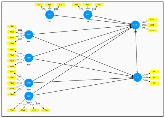
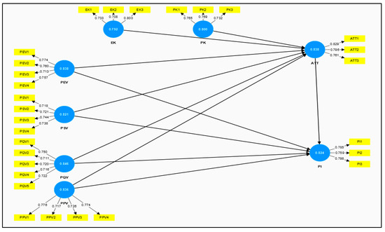
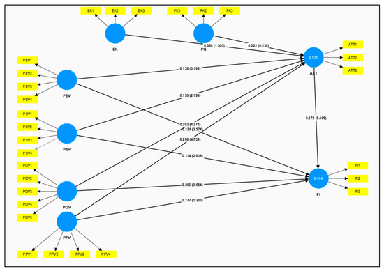
This study aimed to develop a conceptual framework that integrates both consumer-specific and product-specific factors, with a particular focus on consumer value perceptions regarding recycled apparel and their impact on consumer attitudes and purchase intention. The framework combines the Perceived Consumer Value (PCV)
[...] Read more.
This study aimed to develop a conceptual framework that integrates both consumer-specific and product-specific factors, with a particular focus on consumer value perceptions regarding recycled apparel and their impact on consumer attitudes and purchase intention. The framework combines the Perceived Consumer Value (PCV) with the Knowledge–Attitude–Behavior (KAB) model. To validate the proposed conceptual framework, an online survey was conducted with a purposive sample of 716 participants in China. Using structural equation modeling, the hypotheses of the conceptual model were tested. This study identified four dimensions of perceived value and environmental knowledge as significant factors that positively influenced customers’ attitudes toward purchasing recycled apparel. Notably, it was found that perceived quality value had a more pronounced effect on purchase intention than other factors. Interestingly, product knowledge did not demonstrate a significant impact on attitudes. By exploring this under-researched topic, this study provides new insights into consumer behavior in the context of sustainable fashion in a non-Western context.
Full article
The worsening climate crisis has increased the urgency of transitioning energy systems from fossil fuels to renewable sources. However, many industrialized countries are struggling to meet their growing demand for renewable energy (RE) through domestic production alone and, therefore, seek to import additional
[...] Read more.
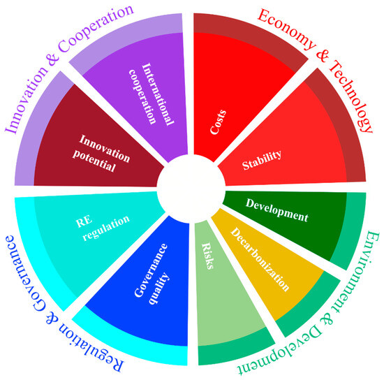
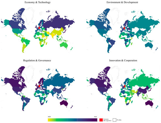
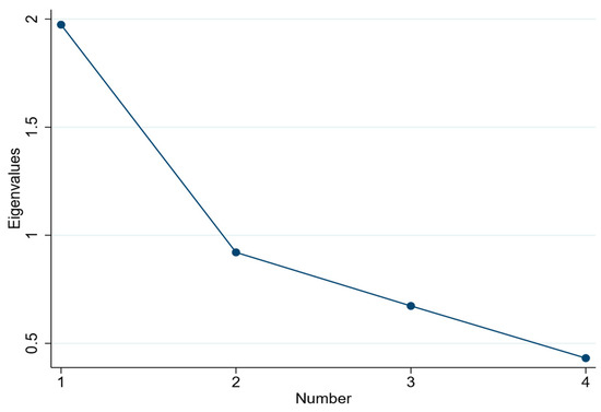
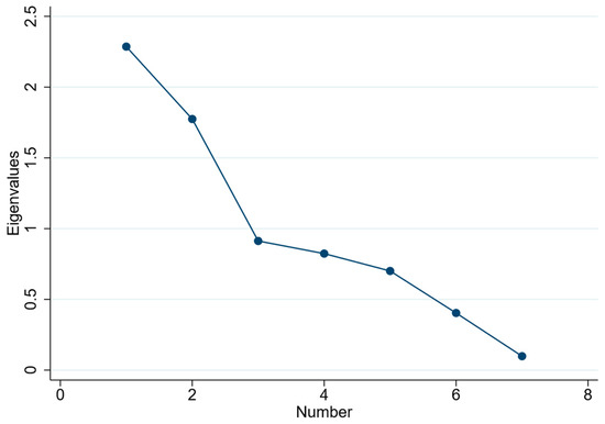
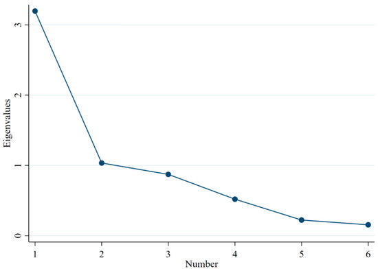
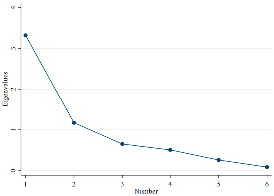
The worsening climate crisis has increased the urgency of transitioning energy systems from fossil fuels to renewable sources. However, many industrialized countries are struggling to meet their growing demand for renewable energy (RE) through domestic production alone and, therefore, seek to import additional RE using carriers such as hydrogen, ammonia, or metals. The pressing question for RE importers is therefore how to select trading partners, i.e., RE exporting countries. Recent research has identified a plethora of different selection criteria, reflecting the complexity of energy systems and international cooperation. However, there is little guidance on how to reduce this complexity to more manageable levels as well as a lack of tools for effective partner evaluation. This article aims to fill these gaps. It proposes a new multidimensional framework for evaluating and comparing potential RE trading partners based on four dimensions: economy and technology, environment and development, regulation and governance, and innovation and cooperation. Focusing on Germany as an RE importer, an exploratory factor analysis is used to identify a consolidated set of composite selection criteria across these dimensions. The results suggest that Germany’s neighboring developed countries and current net energy exporters, such as Canada and Australia, are among the most attractive RE trading partners for Germany. A dashboard tool has been developed to provide the framework and composite criteria, including adjustable weights to reflect the varying preferences of decision-makers and stakeholders. The framework and the dashboard can provide helpful guidance and transparency for partner selection processes, facilitating the creation of RE trade networks that are essential for a successful energy transition.
Full article
by
Carmela Protano, Arianna Antonucci, Andrea De Giorgi, Stefano Zanni, Elisa Mazzeo, Vincenzo Cammalleri, Leila Fabiani, Riccardo Mastrantonio, Mario Muselli, Giada Mastrangeli, Cinzia Lucia Ursini, Delia Cavallo, Diana Poli, Giorgia Di Gennaro, Giuseppe De Palma and Matteo Vitali
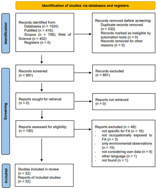
The aim of the present review was to identify all the biomarkers used for assessing the internal dose and the related early effects determined by the occupational exposure to formaldehyde. For this purpose, a systematic review was performed according to the Preferred Reporting
[...] Read more.
The aim of the present review was to identify all the biomarkers used for assessing the internal dose and the related early effects determined by the occupational exposure to formaldehyde. For this purpose, a systematic review was performed according to the Preferred Reporting Items for Systematic Reviews and Meta-Analyses (PRISMA) guidelines. The protocol was registered in PROSPERO (ID: CRD42023416960). An electronic search of Pubmed, Scopus, and Web of Science was performed to collect all the papers concerning the focus of the review and published from the inception of each database until 18 September 2023. Articles were considered eligible if they reported data from observational studies, semi-experimental, and experimental studies on adult workers who were occupationally exposed to formaldehyde, regardless of gender or age. The quality assessment was performed using the adapted Newcastle–Ottawa Quality Assessment Scale. From 1524 articles, 52 were included. Few studies assessed the exposure to formaldehyde in occupational settings through biomarkers, especially by measuring formic acid in urine. The most common approach for evaluating the effects derived from occupational exposure to formaldehyde was the use of the cytogenetic biomarker micronucleus assay in peripheral blood lymphocytes and/or epithelial buccal cells.
Full article


